Sumba Island, an expanse of approximately 10,710 to 10,909.55 square kilometres in East Nusa Tenggara, Indonesia, offers a landscape shaped by ancient rivers and volcanic activity. The island’s topography creates dramatic descents for its waterways, forming waterfalls that cut through limestone and basalt. These natural features define specific regions of Sumba, providing focal points for travel and photography.
Air Terjun Lapopu: A Descent in West Sumba
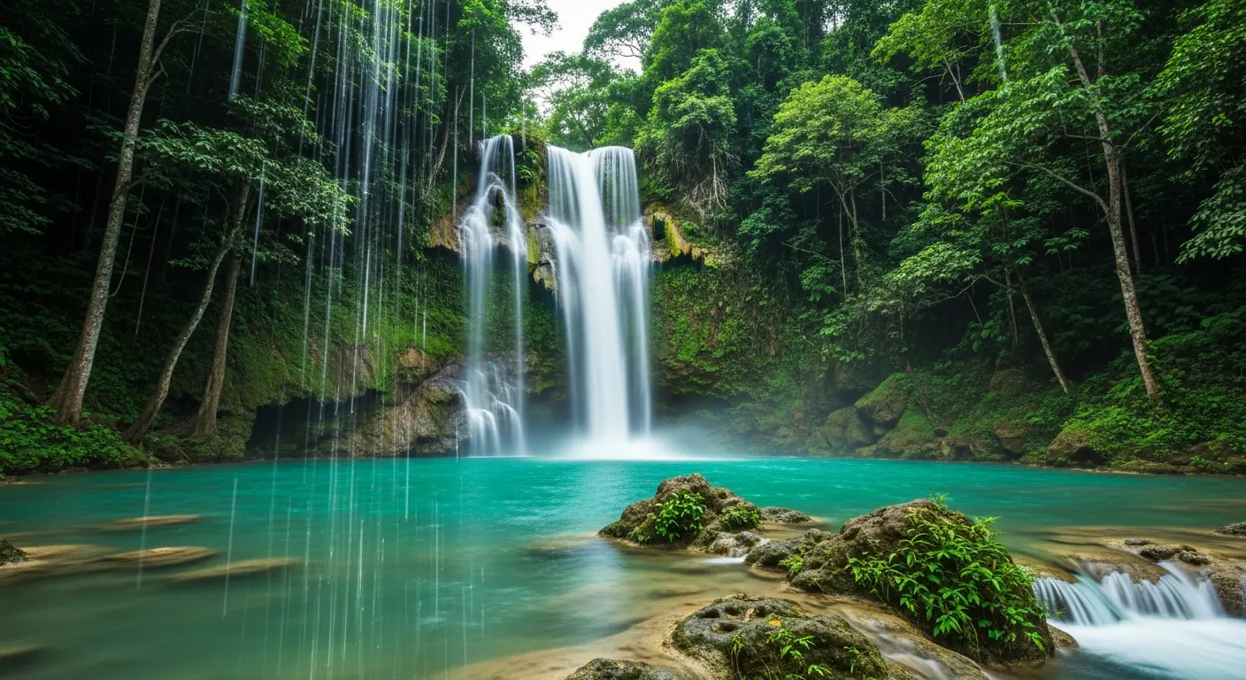
Air Terjun Lapopu stands as a prominent waterfall within West Sumba Regency, its waters cascading approximately 90 metres. The coordinates for Air Terjun Lapopu are about 9.678861°S, 119.492889°E. It is situated within the boundaries of Manupeu Tanah Daru National Park, an area critical for biodiversity conservation on Sumba. Access to Lapopu typically involves a journey from Waikabubak, the capital of West Sumba Regency. The waterfall is located roughly 30 kilometres from Waikabubak, requiring a drive followed by a trek. The path to the waterfall often traverses a riverbed, demanding careful footing, especially during the wet season. The surrounding forest cover maintains a distinct microclimate, contributing to the rich flora and fauna observed in the vicinity. Local guides are available in nearby villages to assist with navigation and provide context on the area’s ecological significance. The flow of Lapopu varies seasonally, reaching its peak volume between November and April. This period coincides with the island’s rainy season, intensifying the waterfall’s presence and altering the landscape with lush vegetation. The limestone formations around Lapopu are indicative of Sumba’s geological history, providing a stark contrast to the verdant canopy.
Tanggedu Waterfall: East Sumba’s Canyon Feature
Tanggedu Waterfall presents a distinct geological formation in East Sumba Regency, characterized by its canyon setting. The waterfall is situated about 50 kilometres north-west of Waingapu, the capital city of East Sumba Regency. Reaching Tanggedu involves a journey by vehicle from Waingapu, followed by a trek through a dry riverbed and over rugged terrain. The path to Tanggedu frequently crosses agricultural land, offering glimpses into local farming practices. The canyon walls, sculpted by millennia of water erosion, reveal layers of rock strata. These formations contribute to the unique photographic appeal of the site. Water levels at Tanggedu are subject to seasonal variations; during the dry months, from May to October, the flow diminishes, exposing more of the underlying rock formations. Conversely, the rainy season brings a more forceful cascade, though access can be more challenging due to slippery conditions and higher river levels. The surrounding area is relatively arid compared to West Sumba, influencing the type of vegetation present. Local communities often manage access to the waterfall, providing insights into the area’s cultural context and environmental preservation efforts. The journey to Tanggedu is an integral part of the experience, with views of Sumba’s characteristic savanna landscapes.
Air Terjun Waimarang: The Secluded Pool of East Sumba
Air Terjun Waimarang, located in East Sumba, offers a different experience compared to the larger cascades. This waterfall is known for its natural pool, formed by the water’s descent into a limestone basin. Access to Waimarang typically involves a drive from Waingapu, followed by a trek that can be challenging due to the uneven terrain and dense vegetation. The path often includes steep descents and requires careful navigation. The water at Waimarang is often clear, creating a striking visual contrast with the dark rock formations and surrounding greenery. The pool’s depth varies, providing different areas for observation. The site is less frequented than Lapopu or Tanggedu, contributing to its secluded atmosphere. The geological composition around Waimarang primarily consists of limestone, which contributes to the formation of the natural pool and the unique rock features. The ambient temperature around the waterfall is generally cooler due to the shade provided by the surrounding trees and the evaporative cooling from the water. Birds and other small wildlife are occasionally observed in the vicinity, indicating a relatively undisturbed ecosystem. The journey to Waimarang requires preparation, including appropriate footwear and sufficient water. The waterfall’s flow is also dependent on rainfall, with the most robust cascades occurring after periods of heavy rain.
Weekacura Waterfall: The Freshwater Spring of Southwest Sumba
Weekacura Waterfall, situated in Southwest Sumba Regency, presents a unique characteristic as a freshwater spring flowing into a series of stepped pools. This site differs from the more dramatic plunges of Lapopu or Tanggedu. The waters of Weekacura emerge from underground sources, maintaining a relatively consistent flow throughout the year, less dependent on direct rainfall. Access to Weekacura usually involves travel from Waikabubak or Tambolaka, followed by a shorter, often less strenuous walk than that required for other Sumba waterfalls. The surrounding landscape in Southwest Sumba is marked by rolling hills and traditional villages, offering a cultural dimension to the visit. The stepped pools at Weekacura are formed by natural limestone barriers, creating distinct levels of water. The clarity of the water is a notable feature, allowing for visibility of the rock formations beneath the surface. The area around Weekacura is often used by local communities for bathing and other daily activities, reflecting its integration into local life. The vegetation surrounding the spring is typically lush, benefiting from the constant water supply. The geological context of Southwest Sumba, characterized by porous limestone, contributes to the presence of such freshwater springs. The site provides an insight into Sumba’s hydrogeology and its interaction with the local environment.
Planning a Sumba Waterfall Itinerary
Integrating Sumba’s waterfalls into a travel itinerary requires consideration of location, accessibility, and seasonal conditions. Air Terjun Lapopu, located approximately 30 kilometres from Waikabubak in West Sumba, is often combined with visits to traditional villages in the region. The journey from Waikabubak to Lapopu takes approximately one hour by vehicle, followed by a 15-20 minute walk. Tanggedu Waterfall, about 50 kilometres north-west of Waingapu in East Sumba, necessitates a two-hour drive from Waingapu, followed by a 45-minute trek. Waimarang, also in East Sumba, typically involves a similar travel time from Waingapu, but with a more demanding hike. Weekacura, in Southwest Sumba, is more accessible, often requiring a shorter drive from Tambolaka or Waikabubak. A comprehensive Sumba itinerary might allocate 2-3 days for waterfall exploration, allowing for travel time between regencies. The road network connecting Waingapu and Waikabubak spans approximately 130 kilometres. During the dry season (May-October), trekking conditions are generally more favourable, though water flow at some waterfalls may be reduced. The wet season (November-April) brings fuller cascades but also presents challenges with muddy trails and increased river levels. Accommodation options are available in Waingapu, Waikabubak, and Tambolaka, serving as bases for day trips. Local guides are recommended for navigating lesser-known routes and for providing cultural context. The average cost for a local guide for a full day can range from 150,000 IDR to 300,000 IDR.
Sumba Eco-tourism and Nature Photography
Sumba offers specific opportunities for eco-tourism and nature photography, particularly around its waterfalls. The varied landscapes, from the savanna of East Sumba to the dense forests of West Sumba, provide diverse photographic subjects. Air Terjun Lapopu, within Manupeu Tanah Daru National Park, offers opportunities to photograph the multi-tiered cascade and the surrounding protected forest. The coordinates 9.678861°S, 119.492889°E place it within a region of significant biodiversity. Tanggedu Waterfall, with its unique canyon formations, presents a different geological context for photography, capturing the interplay of water and eroded rock. The light conditions within the canyons vary throughout the day, influencing photographic outcomes. Waimarang’s secluded pool and Weekacura’s stepped springs provide intimate settings for detail-oriented nature photography, focusing on water clarity and surrounding flora. Responsible eco-tourism practices are important, including adherence to designated paths and minimizing environmental impact. Support for local communities through the engagement of local guides and patronage of local services contributes to sustainable tourism. Conservation efforts in areas like Manupeu Tanah Daru National Park aim to protect the ecosystems that sustain these natural features. Understanding the seasonal changes influences photographic planning, as water levels and vegetation density shift throughout the year.
The waterfalls of Sumba Island, East Nusa Tenggara, offer distinct experiences for travellers and photographers. From the 90-metre cascade of Air Terjun Lapopu in West Sumba to the canyon formations of Tanggedu in East Sumba, each site presents unique geological and ecological characteristics. Sumba Island has an area of about 10,710–10,909.55 square kilometres. Air Terjun Lapopu lies within Manupeu Tanah Daru National Park. Tanggedu Waterfall is about 50 kilometres north-west of Waingapu. Exploring these sites requires careful planning, considering their locations relative to Waingapu or Waikabubak, and the varying trekking conditions. Further information on Sumba and its natural features can be found on Wikipedia (English) and Wikipedia (Indonesian). For details on Air Terjun Lapopu, consult Wikipedia (Indonesian), and for Southwest Sumba, refer to Wikipedia (English). For comprehensive guides and itineraries for these natural attractions, explore the resources available on Sumba Waterfall.